Applications
Burned area bubblegraph
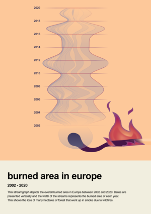
Monitoring wildfires from space is crucial for understanding their impact on climate, including the release of greenhouse gases and aerosols that influence Earth’s system.
This data-driven Little Picture uses satellite data to illustrate the annual pattern of burned area for European countries between 2001–2020. The size of each circle represents the burned area for the individual countries of Europe.
Access the full Little Pictures of Climate gallery
Read more about the competition: Showcase your climate data visualisation talent
Apply here: Little Pictures of climate competition 2023